About This Site
This site is not affiliated with Isle Royale National Park or any official or commercial organization related to the park. For "Official" information on the park, go to the National Park Service website at: www.nps.gov/isro. All of the information presented here is to the best of my knowledge and I cannot take responsibility for what you or anyone else does with it. I am in no way responsible for personal injury, damage to property, or violation of the law in connection with use of this information. I have enough to do just taking care of myself. That being said, I hope you find this site useful.

The island of Isle Royale is located in Lake Superior, southeast of Thunder Bay, Ontario. It consists of the main island, which is 45 miles long and up to 9 miles wide, but the full park area encompasses a total area of 850 square miles, including submerged lands, which extend 4.5 miles out into Lake Superior. Besides the main island it is surrounded by about 400 smaller islands. The parks total area is 571,796 acres, divided between 133,788 acres of land, and 438,008 acres of surrounding Lake Superior waters. Approximately 200 inland lakes and ponds are scattered across the island, as are numerous bogs and marshes. Moist cool conditions near the shoreline and in the northeastern portion of the park support a northern boreal spruce-fir community, while somewhat drier conditions in the park’s interior and southwestern portion favor northern hardwoods like sugar maple and yellow birch. The main island contains a series of parallel ridges and valleys and a shoreline marked by numerous islands, narrow peninsulas, and bays. Ridges run southwest-northeast, generally with moderate slopes on the southeast aspect and steep slopes or cliffs on the northwest side. The highest point in the park is 1394 feet above sea level, almost 800 feet above Lake Superior.
Top
Isle Royale National Park was authorized by Congress in 1931 "to conserve a prime example of North Woods Wilderness". The park was designated as part of the National Wilderness Preservation System in 1976, under the Wilderness Act, and remains today, as an example of primitive America. Ninety-Nine percent of the park's land area is designated as wilderness. In 1981, Isle Royale was designated as an International Biosphere Reserve, by the United Nations, giving it global scientific and educational significance. Accessible only by boat or float plane, Isle Royale is relatively untouched by direct outside influences and serves as a living laboratory.
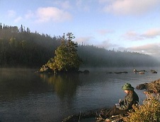
beaver lake and lake superior from the minong ridge trail.
The island has been used and enjoyed long before the arrival of Europeans. There are ancient pits used in the gathering of copper and hundreds hammer-stones have been found that were used to pound out the copper. Native American copper objects formed from the island's copper, have been found throughout North America. With the explorations of Douglas Houghton and others, word was spread of the existence of copper on the island, and during the 1800's, a lot of mining exploration was done and several successful mines operated. With the mines, came the establishment of towns and communities built around the mines. Most were short lived, but there are many remnants of these sites.
Fishing has also always been a part of the island. From the Native Americans, to present day, the island and its waters have provided both food and a living to people. Commercial fishing began in the 1800's, and continued until the 1960's, when the fishing industry was hurt by the introduction of the Sea Lamprey and Salmon into the lake. It continued, in a limited way through the Sivertson, Strom and a many other families, but all of the fishing licenses are now gone. It was also a vacation destination for many and many of their “camps” remain and continue to be used by their descendants. Through the continued presence of the descendants of families that settled and lived on the island, the knowledge, heritage and a way of life is still preserved.
john's hotel on barnum island, 2012. the first hotel on isle royale. built 1887-1892. currently being restored.
The park is open to the public from approximately April 15, through the month of October. However, the Ferrries and Seaplane services run from early May, through early October. Isle Royale National Park is one of the few national parks to close during the winter. The closure is due to the extreme winter weather conditions, for the protection of wildlife, and for the safety and protection of visitors. The Park Headquarters for the winter is located in Houghton, Michigan. The summer headquarters is located at Mott Island on Isle Royale National Park.
the ranger iii in rock harbor.
There are over 165 miles of hiking trails on the island, ranging from easy to difficult. Besides Lake Superior, there are many inland lakes with relatively easy portages, if going by canoe or kayak. It is the least visited National Park, but has the most repeat visitors. More people go to Yellowstone National Park in a day, than go to Isle Royale in a year. Due to its location, it is not an easy place to go to and takes quite a bit of planning to get there.
rock harbor trail near three mile campground.
Once on the island, there is very little available, so you should try and bring everything you need with you. There are stores at both Windigo and Rock Harbor that have limited supplies available at a premium price. They are open from approximately Memorial Day to Labor Day. There is lodging available in Rock Harbor in the form of rooms at Rock Harbor Lodge and Housekeeping cabins. In Windigo, there are two cabins available for rent. Reservations are required. The lodging is operated by Forever Resorts and full information can be found at rockharborlodge.com.
rock harbor store, ranger station and docks.
Source: National Park Service and overall general knowledge.
I have been to the island of Isle Royale over twenty times now. It has made an indelible mark on my life and consciousness. It's wild desolate beauty leaves a feeling you can never forget. To be in a place, miles from civilization, without the existence of a phone, with only what you are carrying to survive with, is something that can only be experienced. The variety of plants and terrain that can be seen by merely heading in a different direction, or simply walking on, is quite unique. From the bare weathered rocky North shore to swamplands, high ridges, to numerous lakes and islands, the island has it all. The animals present on the island, are moose, beaver, snowshoe hares, squirrels, fox, wolves, ducks, loons and various bird species. You are almost guaranteed to see moose and fox. If you are lucky, you might hear the wolves, and if very lucky, you might even see one (they will see you).
the author writing at chippewa harbor.
I am always getting the question, and thinking myself, about why I keep going back again. I could go so many other places to experience different beauty and have been to many places. I am not sure how to answer this to people, or even to myself. I know that I want to go there, and when I come back, I look forward to going there again. I believe it is a feeling you can only know by having been there. It is so isolated from the world and the feeling is one of independence and wilderness. I have seen majestic views from very many places, but love to come back to the simple view of a lake with loons gliding across. To watch the island grow and breathe is a simple joy. And it does both. When late at night, in the total silence, you can feel it breathe and literally hear it breathe. When coming back to it, you can see how it grew. I guess, the best way to put it is, I have never experienced any day on the island that was the same as any other day. It is always different, from day to day, from year to year. It is always breathing, always changing.
grace harbor sunset from a backcountry camp.
Isle Royale Info Book
This site is based around my book, "Isle Royale Info - A Comprehensive Guide to Isle Royale National Park". I started writing about the island in 2001 because I did not find the information I wanted about the island. There was information out there, but I wanted more details. It began as a personal reference for myself while planning and documenting trips. I shared the information with others through a web board I was moderating and decided to put the information into one document to share. Thus began the "Isle Royale Info" project. From then on, I was not just taking trips to the island, I was taking trips with goals and gathering information. Once I felt I had a fairly complete guide to most everything on the island I released the "Isle Royale Info - A Comprehensive Guide to Isle Royale National Park" in January, 2011. The book was released in several configurations from a basic printable PDF file to a PDF file with links to full color pictures, charts and maps.
base camp program main screen.
The book was always being updated so, the problem I had was sending new versions to everyone who had previously purchased it. My solution was to put the latest version of it on a server and let people update it as needed. So, as of the third release in April, 2013, the book has been updated to include a user interface called "Isle Royale Info - Base Camp". This interface provides a way of viewing and updating chapters and pictures and a few other things. There is also a neat little utility called the "Isle Royale Trip Planner" to assist in planning routes and destinations.
Selecting "Isle Royale Info Book" from the main menu to navigate to:
● book description to see a full description of the book and the individual sections along with some samples of some of the book.
● program description to see a full description of the programs "Base Camp" and "Trip Planner" along with some screen captures.
● user's manual to read the programs documentation.
● demo program to download a free demonstration version of the book and programs.
● revision history to see the history of the program and the current versions.
Itinerary Generator
The Itinerary Generator is a program created to help you plan your trip to Isle Royale National Park. It will create and save an Itinerary based on your selections, allow you to load and view the itineraries you have created, create and print a permit based on it and generate a trip package with information on the trails and campgrounds on your route.
Select "Itinerary Generator" from the main menu to navigate to:
● program description to see a full description of the program and view a video demonstrating an overview of the program.
● user's manual to read the programs documentation including full screen captures.
● revision history to see the history of the program and the current versions.
explore itineraries screen.
Planning a trip to the island can seem daunting when you first look into it. There are very few ways to get there, but a lot of possiblities once you are there. These menu items should provide a lot of information to help you plan your trip.
Select "Planning Tools" from the main menu to navigate to:
● planning a trip to see a quick synopsis of the possible ways to get to the island and things you need to do in planning a trip.
● trip packages to see complete packages available for common routes on the island. They were created in response to the most common question I receive, "What route do I choose?". Each package provides details on the route including maps, pictures, trail descriptions, campground descriptions, suggested routes based on days and details on some points of interest along the route.
● miles chart is a small utility program that provides a chart of the hiking trails on the island. It is based on the chart created and included in the book. The program displays the same chart, but when you move the cursor onto it, it highlights the items selected and displays a small dialog with the milelage and two destinations.
● links will display links to various sites related to the island. This includes all of the ferries and the Park Service site. If you are planning a trip, the key one is the Isle Royale Forums which is a web board with absolutely the most knowlegable people regarding the island. This is the place to discover information or, ask questions.
paddling on siskiwit lake.
Select ir tube to view some videos I have shot on the island. I have shot hundreds of hours of video while on the island during various trips and released one full length video on VHS (I am no longer offering it because it needs to be remastered to DVD). I hope to be releasing other full length videos someday, but I do not know when I will get time to do it. For now, I just keep shooting footage. In the meantime I have decided to share some clips. They are, for the most, part "clips" with quick titles describing what they are. Enjoy!
recording on the back of the voyageur ii.
Select store from the main menu to see the items available through this site. This includes the Isle Royale Info book, the Itinerary Generator program and other items related to Isle Royale.